Escape - Chembra Peak trek, Waynad.
11:01 AM
At a height of 2100m, Chembra peak is the highest peak in Waynad, Kerala. The peak is located near the town of Meppady and is 8kms away from Kalpetta. Permission from the forest office in Meppady is required for trekking up to Chembra Peak.
Preparation of the trek:
Trekking details:
Base camp: Kalpetta or Meppady
Connectivity from Bangalore: Well connected by Govt buses.
Journey hours: 7-8 hours in bus.
Trekking distance: 3-4 kms
Trekking season:
October- March.
Difficulty level:
Preparation of the trek:
As most of our treks, this trek was also decided spontaneously. First we had decided for a camping at Gunjoor lake. But the plan was changed to Waynad. We were 6 people, 3 girls and 3 boys from Bangalore. We had booked a private vehicle since estimated cost of travelling by Govt bus and car turned out to be almost same.
Trek day 1:
 |
| Soochipara falls. |
We left from Bangalore at night 11. Road to Waynad passes from Bandipura forest which is closed at night time. So, plan your travel accordingly so that you reach Bandipura forest in the morning. We reached Bandipura at morning 5 and waited there till 6. Gates open at 6am. From there Waynad is about 2 hours journey, we reached Waynad at 9am. We hired a room at Kalpetta. Room costs around 700-800rs. Since we were already late we decided to take trek on the second day. So, we had the entire day to roam. And the first choice of ours was a falls. Meenmutty falls was closed because of heavy rains. So we decided to goto Soochipara falls. Soochipara falls is about 7-8 kms from Mappadi, takes around 20min of driving. Once you reach parking lot you have to pay parking fees and entrance fees to the falls. Reaching falls again takes about 1-2kms of walk on a neatly maintained rock surface. We spent around 1-2 hours in the falls.
Our next stops were Pookote lake and and Banasura dam. These places are nearby Kalpetta and Meppady and if you have own vehicle its convenient to travel as you need not rely on local transport or jeeps. All these places have entrance fees and parking fees. You can go for pedal boating or Kayaking at Pookote lake.
Trek day 2:
 |
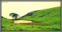
| Heart shaped lake |
We started early in the morning at 8. Chemra peak is nearby Meppady and the hilly drive takes you through breathtaking tea estates on both the sides. you have to drive through a private property to go the peak. There is a forest department office on the way where you have to take permission for the trek. Permission costs 500rs and the forest department provides the guide. You have to park vehicle 2-3 kms after the forest department. And trek starts from here. You have to walk around 300-400 meters to the view tower. from here you can see the town Meppady. The view tower is at a height of 1100meters while the summit is at 2100 meters. So, you have to make a net climb of 1000meters to reach the summit. Summit is around 3-4 kms from the view tower.
 |
| A barn with Chembra peak in the backround |
The actual trek starts from the view tower and passes through a dense forest for around half a km. Even though we went in the month of July during heavy rains, we actually didn't find any leeches but I heard someone screaming with the leech bite. After the forest trek goes for around 1km covering grassy hills and you reach the famous Heart shaped lake. When we reached here it had started raining heavily and thanks to our prior planning we had raincoats. But the cloud was so thick that visibility reduced to less than 10meters. As the rain was getting heavier guide told us that he will not take us to the peak since the rain causes slippery land and its dangerous. However he agreed to take us to the next hill previous to the peak. As we were climbing each step rain had caught us even through our rain coats. Path was amid tall grass and it was giving us the experience of Anaconda movie. We climbed the next hill and decided to climb down since it was getting slippery.
Climbing down wasnt easy either because of the wet soil and the slippery rocks. It took us 2 hours to climb up and 1 and half hours to climb down. We were at the view tower by 1pm. We had our lunch at the view tower. View tower is well equipped by toilets and water facility.
Base camp: Kalpetta or Meppady
Connectivity from Bangalore: Well connected by Govt buses.
Journey hours: 7-8 hours in bus.
Trekking distance: 3-4 kms
Trekking season:
October- March.
Difficulty level:
Easy for frequent trekkers.
Moderate for amateur trekkers.
Must carry:.
Total trekking time:
Tips for photographers:
Must carry:.
- Good trekking shoes.
- Water(1lt).
- Leech repellent if you are going before november( Iodex spray, salt).
- Proper winter wear if you are going after Nov. Temp stays low in winter.
- First aid kit, energy drinks and food items.
- Reserve your tickets in advance.
- Start trekking early in the morning, sooner the better.
- Stay with the crowd always.
- Keep your backpack as light as possible. Dont carry too much food.
Total trekking time:
- If you are a frequent trekker, you can reach the summit in 2 hours.
- for amateur trekkers it might take 3 hours.
Tips for photographers:
- Dont forget to capture the macro beauties of the jungle.
- View from the mountain gives a perfect landscape.
- Trekking without the forest dept permission is punishable.
- Do not carry alcohol. Do not smoke in the jungle
- Do not throw anything during the trek. Keep the trekking place clean for the following trekkers.
Happy Trekking :)


1 comments
Very useful post. keep sharing post like this. A place for nature lovers and tourists alike, Kalpetta is a quaint little town located in the Wayanad district of Kerela. The city is covered in lush coffee plantations and embraced by lofty mountains. Check out more about Chembra Peak.
ReplyDelete